
ALTIPLANO PART 1: SAN PEDRO DE ATACAMA
It's been about two months now since we returned from South America, and our trip across the Altiplano from San Pedro de Atacama in northern Chile to Lake Titicaca in Bolivia. As I wrote in my previous blog about the trip, it's a place I've wanted to see for about as long as I've been interested in photography. It's a genuinely remote and extreme part of the planet with landscapes that look like they belong on Mars rather than our own green and blue planet.
We flew to Santiago de Chile via Madrid, one of the longest single flights I've ever done. Not only do you cross the Atlantic Ocean, but also the whole of the south American continent and move from the northern hemisphere to the south. We flew overnight, arriving in Santiago early in the morning and caught the bus to the centre of the city. It's always said that Santiago is South America's most European city, and although I can see why people say that, to us it really didn't feel particularly European. It's incredibly wide streets have all the signs of a city that was built for cars like most of the cities I've seen in both North and South America. Still, we'd decided to stay for a night, and soon found our room in the Lastarria district. We spent the afternoon wandering around the city, trying the food and enjoying the atmosphere before having a great meal in the evening.
The following day we got up early and headed back to the airport for our flight to the northern city of Calama. At one point we flew along the edge of the coast, and looking down we could see how the Atacama desert continues all the way to the edge of the sea. Turning back inland the rocky landscape below looked like another planet, and the small city of Calama really felt like an outpost in the middle of nowhere. The airport though is brand new and looks like it's recently been rebuilt or expanded to cope with what Chile obviously expects to be a major increase in tourism to the area. We quickly found a minibus to take us the 90 minutes to the small town of San Pedro de Atacama where we'd planned to spend the next 4 nights. It's a pretty town, all low adobe buildings built around a few narrow streets and a lovely square. It's also completely geared towards tourism and exploring the surrounding area, but despite this it's still has a lot of charm. San Pedro makes an ideal base to start exploring the region as there's so much to see in the surrounding area, and at the rather moderate height of 2500 meters it's a good place to get acclimatised by making excursions into the higher Altiplano of around 3500-4000 before coming back to into the town at night to rest.
We checked into our hotel and then headed out to explore, but as all the excursions leave either in the morning, or at 15h in the afternoon, and we hadn't picked the hire car up yet, there wasn't really much we could do apart from have a look around the town.
The next day we headed out to the nearby Valle de la Luna. We spent the afternoon exploring there, walking along rocky ridges that overlooked the amazing valley and wandering between huge dunes. It's an atmospheric place, and one we could easily have spent days exploring and photographing.


It was also our first taste of the incredibly strong sun at this altitude, and we were surprised by the heat and how easy it was to burn. Hats are an absolute essential here. At the end of the afternoon we headed up to the ridge overlooking the valley, San Pedro and the Altiplano ridge that rises in the east culminating in the 6000 meter peaks of Licancabur volcano and the more distant Lascar. The view from here was absolutely stunning, and although it felt like the entire town had come up to the ridge with us, we enjoyed the atmosphere and wandered away from the crowds to capture the last light and colourful skies above the Altiplano peaks. It was a breathtaking view, and a moment when we really felt lucky to be standing in front of such amazing scenery in such an amazing place.
The following day we were up early to go and collect a jeep we'd arranged to rent from the local Europcar. We were soon heading out of town south on Route 23 across the low plains, and then slowly ascending along the ridge that marked the beginning of the Altiplano. The landscape really was incredible, with open plains to the south and west of us, and mountains and peaks to our left in the east.


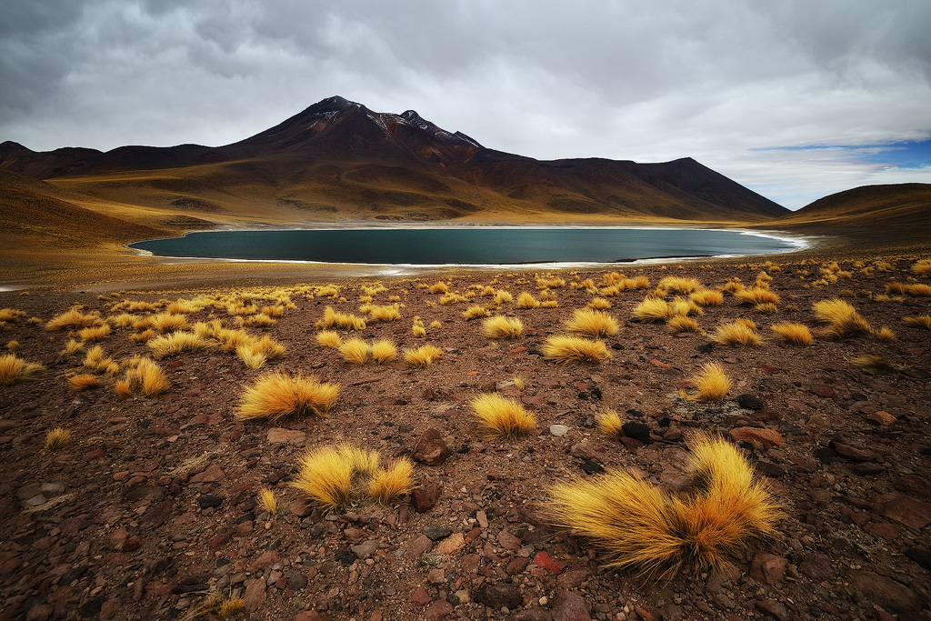
We were heading for the southern lakes of Miscanti and Miniques, places I'd seen photographs of and was keen to see for myself. As we drove, the landscape became more and more barren, and we started to feel the pressure as we ascended past 3000 meters and continued up to 4000. The road curved up towards towering volcanic peaks until finally at the very top of the ridge we came to the entrance of the park. It was pretty much deserted, but sadly the weather was overcast with thick heavy clouds, which surprised me as in every image I'd ever seen of the place the skies had been clear blue. Cloudy weather isn't usual in the Altiplano as it is such a dry place that there is rarely enough water vapour to condense into clouds, so whilst is was interesting to see the lakes in such unusual conditions, it was also disappointing to have no direct light to brighten all the colours. We spent a while walking around the two lakes, and sat down to have lunch overlooking the smaller Laguna Miniques. It was pretty cold, and the altitude was a little wearing, but the view and the isolation was amazing.


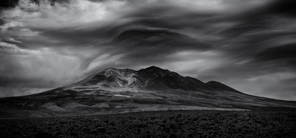
After an hour or so we left the park and started heading north to the Salar de Aguas Calientes. It was a location high on my list for the area, the images I'd seen of the colours looked absolutely amazing and I was eager to see it for myself. We were soon leaving the road again and heading off up another unmarked dirt track, but unfortunately we missed the unsignposted turn off to the Salar and it was about 30 minutes before we realised. By the time we got back to the track we wanted to be on, we'd lost an hour and I started to realise that there was no way I'd get to where I wanted to be going in time for the sunset. As we headed along the dirt track, I noticed that although we were once again under heavy thick cloud, I could see that back in the west, there was clear sky above the horizon. However, as we continued to drive eastwards into the Altiplano, we started to ascend towards the 6000m peak of Lascar Volcano which was scraping the bottom of the clouds, and once we had passed it the sky became very murky. I realised that it would be impossible for the sun to squeeze any light between the low cloud and the high ridge we had just crossed. We continued heading east as I was determined to see Laguna Lejia before turning back, and after what seemed like forever driving across some incredibly rough terrain we saw the small lake surrounded by towering volcanic peaks. I got out to take a few shots...it was incredibly cold and the wind took my breath away. I quickly set up the tripod and noticed llama or vicuna tracks circling the lake. It was astonishing that a mammal could find enough food to live on in such a barren, uninviting place.


I headed back to the jeep (Teresa had sensibly stayed inside) and we turned around and headed back west the way we had come.
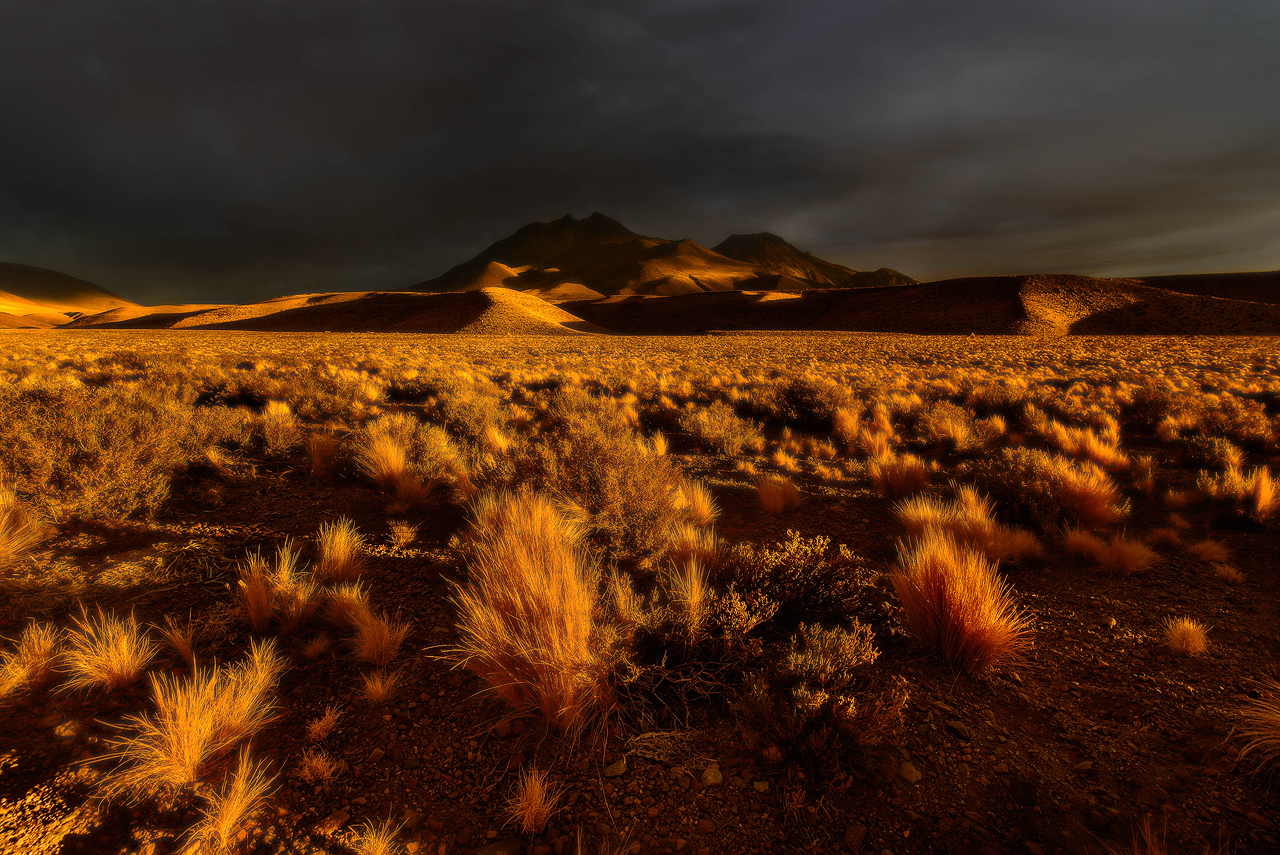
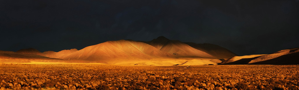
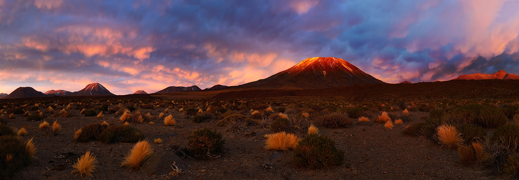
I had an idea that although the sunlight would never reach us where we were, if we could get back to the ridge that descended back to the lower plain of the Altiplano, the sun would paint the side of the ridge and their west facing peaks with the day's last light as it passed through the gap between the far clouds and the horizon. It became a bit of a race, but a few minutes after we'd crossed the ridge and were descending south of Lascar, the sun did indeed fall into the tiny patch of clear sky to the west and the whole world erupting in golden light. The dry grass that covered so much of the plain was illuminated, and I quickly stopped the jeep and jumped out to take some photos of some of the most dramatic light I had ever seen.
When I'd finished I climbed back in the jeep content to head home. However, the day had another surprise for us and we hadn't gone more than a kilometre when the sun, just now touching the far horizon, started to paint the underneath of the incredibly dense clouds above us a deep red. Again, I stopped the jeep and started to photograph. Where before the whole scene had been gold beneath an almost black sky, now the whole world was different shades of red and pink everywhere we looked. Teresa was laughing because by sheer chance we were in an astonishingly beautiful place surrounded by majestic peaks. On our left, Lascar towered above us, and to the south east, the beautiful peaks of another volcano turned red beneath an incredible sky.
We photographed, shot some video, and then when the last colour had drained from the sky, headed back home to San Pedro in the dark. We arrived a little after 7, just in time for dinner and then an early night.
The next morning we'd planned to head up to the hot springs at Puritama. It was a drive north along the edge of the Bolivian border past some more astonishing peaks, and then arriving at a tiny valley filled with lush vegetation and a stream of hot water running through it in the midst of such dry barren landscape was amazing. We found a quiet pool, then made our way upstream through the bushes to another pool with a small waterfall flowing into it. It was wonderful to spend an hour bathing in the warm water, ducking under the waterfall, and basically just relaxing.
At lunch we headed back to San Pedro, picked up some lunch, then headed east towards the borders with Bolivia and Argentina to the relatively modest peak of Cerro Toco. It's by no means a beautiful peak, but it looks out across Volcano Licancabur and there's a dirt track which can be driven to just below the summit leaving a short walk to the peak. The road up there was another very bumpy dirt track, and as we left the main road far behind and the road climbed higher and higher, it really felt as though we were travelling at the end of the world.
As we passed the 5000m mark, the road got a lot steeper and I noticed that just before we reached the trail head, we passed a small scientific research station with a parabolic dish pointed at the stars. We continued up to the point where we would have to get out and walk, and by now the track was very narrow. I realised that turning around in the dark after sunset would be tricky, as one side of the track was a very steep drop into a valley so I decided to try to turn round then. To cut a long story short, the jeep ended up getting completely stuck, and the only way we could move was straight down the side of the valley, which would most likely have turned the car over. We were really high, and doing anything energetic was extremely exerting and left us panting for breath, so we decided to walk down to the scientific research station we'd seen earlier and hope there was someone there. If not, we'd walk all the way to the road and see if we could hitch a lift. My main concern was that we were meeting our guide in Bolivia the next morning, and needed to get the rental jeep back, so I was concerned that we might miss the meeting if we had to come back up the mountain to rescue the jeep the following day.
We arrived at the research station, which I later discovered was the Atacama Cosmology Telescope (ACT) and had a look round. It appeared to be deserted, but eventually we came across the 3 scientists who were working in a hut. They had a couple of jeeps, and helped us get our own unstuck before offering us a very welcome cup of coffee. We'd been incredibly lucky, as 20 minutes later and they would have left and headed down the mountain for the evening.
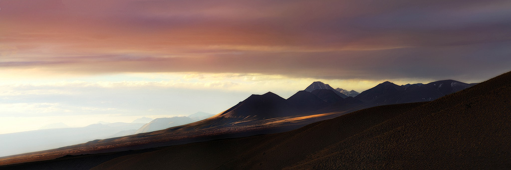
Giving up for the day, we decided to head back to town and get an early night, stopping on the way to photograph the day's last light across Licancabur Volcano.
We were back in town just as night fell, and made the most of our comfortable hotel. The next day we were going into Bolivia and would be spending 4 days bouncing around in the back of a jeep and sleeping in some very remote hostels.